In a world where the size of shopping complexes, hospitals, airports, and other public spaces is expanding rapidly, the need for efficient navigation has become more crucial than ever. The growth in purchasing power has resulted in larger malls and multifaceted indoor areas, presenting a challenge for visitors to easily locate their favourite stores or destinations amid the hustle and bustle. The importance of seamless indoor navigation is rising, and the concern is not about finding the right store but ensuring a smooth experience for every visitor. Whether the concern is about avoiding crowds, locating a specific venue, or enhancing safety measures, the solution lies within the “Indoor navigation & positioning system.” In this blog, Zethic will guide you on how to create indoor navigation maps and positioning systems for large buildings, helping you understand how these solutions can make events run more smoothly.
How Does An Indoor Navigation System Work?
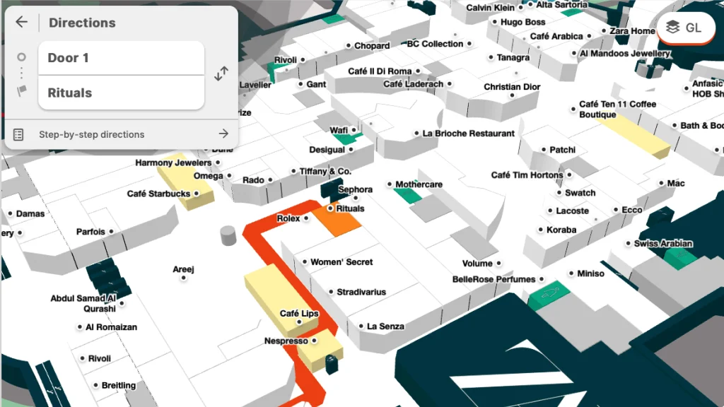
A seamless indoor navigation system hinges on an accurate digital Maps. 3D digital maps incorporate pathing to establish the most efficient routes. Once pathing is in place, users can easily define start and end points, initiating single or multi-floor navigation with turn-by-turn guidance from any predetermined location on the map. Users access this functionality through websites, mobile apps, or strategically placed digital directories within venues, providing a user-friendly experience for efficient navigation.
Objectives
Digitize the Physical Space:
Our initial goal in the field of indoor navigation is to digitally bring the entire mall to life. This includes not only mapping rooms and corridors but also capturing the essence of critical facilities, equipment, and maintenance sites. We leave no nook or corner unexplored in our pursuit of a complete and detailed internal navigation system that guarantees every facet of the mall is taken into account.
Enhanced Visitor Experience:
Our goal is to make every visit to the mall a pleasant one. To that end, we are developing an easy-to-use indoor mapping tool. Consider it a helpful guide for guests, assisting them in easily finding their route, discovering businesses, and gaining access to services. The objective is to improve the whole shopping experience by making navigating a fun and easy component of the process.
Augmented Reality (AR) Integration:
Augmented Reality (AR) integration opens up a new level of interaction. This enchantment adds navigational markings, commercial content, and interactive information to the real-world surroundings. The goal is to present visitors with an interactive and visually enhanced experience that will change how they interact with the mall and its services.
Operational Efficiency:
Our indoor mapping and location technologies help to operational efficiency in addition to the visitor experience. Real-time analytics reveal useful information about visitor traffic and activity trends. This data is then utilized to improve mall operations by optimizing crowd flow and resource allocation. As a consequence, both visitors and mall management benefit from a smooth and efficient retail environment.
Personalized Recommendations:
Our applications go beyond navigation by adding a personal touch. They research the visitor’s tastes and shopping history to make personalized recommendations. Consider a shopping experience in which customers are steered not just to any store, but to ones that exactly match their preferences, resulting in a more customized and pleasant encounter.
Emergency Navigation Assistance:
Safety is critical, and our applications go above and above to assure it. In the event of an unexpected incident, emergency navigation help comes to the fore. This function directs visitors to exits and safe zones while delivering real-time updates and directions. The idea is to keep everyone in the mall informed and safe in the event of an emergency.
Features of Indoor Navigation System
In the realm of indoor navigation maps and positioning, our application boasts a range of features designed to elevate the user experience and streamline operations. Let’s explore these features in detail.
Interactive Mall Maps:
Immerse yourself in the mall experience with detailed and interactive floor plans. These showcase various levels and sections, empowering users to explore and navigate seamlessly through the mall environment.
Indoor Positioning:
Our application employs cutting-edge indoor positioning systems. Leveraging beacons or Wi-Fi access points, it delivers real-time, accurate location information within metres to mobile apps. This not only enhances indoor navigation maps but adds significant value to the overall navigation experience.
Indoor Navigation:
Navigate with confidence. Our accurate route navigation is a boon for service workers, office employees, and visitors alike. It ensures quick and efficient navigation within any facility, prioritizing safety and security for public safety responders.
Location Sharing:
Accurate location sharing is a game-changer. It facilitates the immediate resolution of service calls, enhances safety, and expedites security response. All these functionalities are unified in a comprehensive, location-based tracking system.
Top Searches:
Unlock insights into visitor preferences with our top searches feature. Discover what locations visitors are searching for most frequently, using missed searches to determine potential additions to your venue.
Locate Key Points of Interest (POIs):
From vending machines to security desks, our application helps users locate key points of interest effortlessly. POIs cover a range of amenities, including bathrooms, elevators, ATMs, and parking spaces.
Search:
Efficiency meets convenience with our search feature. Users can search through shops by category, brand, or product, with a dynamic dropdown menu based on analytics, ensuring the most popular choices are readily accessible.
Store Details:
Get an in-depth look at each store. Our application provides detailed overviews, including working hours, descriptions, categories, phone numbers, and more.
Directions:
Navigate from point A to point B seamlessly. Users can receive text or step-by-step directions, with the added ability to include stops along the way.
Parking Assistance:
Stay ahead with real-time updates on parking availability and directions to the nearest open spots. Parking becomes a breeze with our application.
Event Calendar:
Stay in the know with details about upcoming events, promotions, or entertainment activities within the mall. Our application keeps you informed and entertained.
User Accounts:
Enjoy a personalized experience with user registration and login. Save preferences for a tailored visit every time.
Social Sharing:
Share your experiences effortlessly. Our integration with social media platforms allows users to share their findings and experiences seamlessly.
Multilingual Interface:
Cater to diverse users with language options. Our application ensures that everyone, including tourists, feels at home in the mall environment.
Analytics and Reporting:
Gain valuable insights into user behavior, popular areas, and trends within the mall application. This information fuels continuous improvement, ensuring the application evolves to meet the dynamic needs of users.
How do you create indoor navigation map applications?
Implementation Plan:
Our implementation plan is not just a roadmap; it’s a commitment to transforming your mall experience.

Phase 1 – Requirement Analysis and Planning (2 Weeks):
In the initial phase, we prioritize understanding the unique dynamics of your mall premises. Through a comprehensive analysis, we gather specific requirements that will shape the foundation of our application. This phase is crucial for laying the groundwork, and we meticulously strategize the implementation plan to align with your vision and objectives.
Phase 2 – Application Development (20 Weeks Approx.):
The heart of our transformation lies in the development phase, spanning approximately 20 weeks. Here, we bring the Indoor Mapping and Positioning Application to life. Our dedicated team works tirelessly to ensure the seamless integration of all proposed features. The focus is not just on functionality but also on optimal performance, ensuring a robust and user-friendly application that exceeds expectations.
Phase 3 – Testing and Optimization (2 Weeks):
Quality is paramount. In the testing and optimization phase, lasting two weeks, we subject the application to rigorous testing protocols. Usability tests are conducted to gauge the user experience, and feedback is actively sought and implemented to refine the application further. Our goal is to deliver a flawless and intuitive application that guarantees user satisfaction.
Phase 4 – Deployment (2 Weeks):
As we approach the final phase, meticulous attention is given to ensure the application meets defined standards. The deployment phase, spanning two weeks, involves systematic checks and balances. We meticulously deploy the application on live servers, guaranteeing a smooth transition from development to a fully operational and user-ready system.
From understanding your unique requirements to crafting a feature-rich application, testing it rigorously, and deploying it seamlessly, every phase is geared towards delivering excellence. Get ready to witness the evolution of indoor navigation in your mall, providing visitors with an unparalleled experience.
Applications Of Indoor Mapping And Positioning Application
Educational Spaces
In schools, from K-12 to universities, indoor navigation maps are safety keystones. These interactive layouts aid in emergencies and provide administrators with easily shareable, up-to-date maps during changes like renovations.
Colleges and Universities
On sprawling campuses, indoor navigation isn’t just convenient—it’s vital for safety. Real-time communication and adaptability to changes make these maps essential for a smarter educational environment.
Fire Departments
Indoor mapping is a game-changer for fire departments, offering frontline responders precision navigation in complex spaces. From pre-incident planning to optimizing safety operations, these maps enhance decision-making for a safer response.
Fan-Friendly Stadiums
In stadiums, indoor navigation maps simplify the visitor experience, guiding fans and offering customized suggestions. The flexibility for quick updates accommodates different events or layout changes, ensuring a seamless experience.
Airport
Airports benefit from indoor navigation maps that streamline traveler journeys, guiding passengers efficiently and eliminating unnecessary stress. Finding services, products, or boarding gates becomes a smooth process with these navigation systems.
Smart Offices
In the era of smart offices, indoor navigation maps are crucial for creating efficient workplaces. Integrated with Wi-Fi and mobile apps, they contribute to a seamless user experience, enhancing navigation in office buildings.
Navigating the Future: Zethic’s Cutting-Edge Indoor Mapping & Positioning System
In a world of expanding public spaces, efficient indoor navigation is crucial. Zethic‘s Indoor Mapping & Positioning System addresses this need, providing smooth navigation in large buildings. Our blog explores the working of our indoor navigation system and its objectives, emphasizing the digitization of physical spaces, enhancing visitor experiences, integrating Augmented Reality, ensuring operational efficiency, offering personalized recommendations, and providing emergency navigation assistance.
We delve into the features of our application, including interactive mall maps, indoor positioning, navigation, location sharing, top searches, locating key points of interest, search functionality, store details, directions, parking assistance, event calendar, user accounts, social sharing, multilingual interface, and analytics and reporting. The blog also outlines a comprehensive implementation plan spanning requirement analysis, application development, testing and optimization, and deployment.
We conclude by highlighting the applications of indoor navigation mapping and positioning in educational spaces, colleges and universities, fire departments, fan-friendly stadiums, airports, and smart offices. Zethic’s commitment is to deliver an unparalleled indoor navigation experience, ensuring safety, efficiency, and user satisfaction in diverse environments.